June 18,2001
Log: Isle Mujeres Mexico
No wind
Seas calm
12:30 AM a freighter is in our danger sector off our starboard bow. It is difficult for me to interpret it’s lights in the black of the night. Thankfully the radar is working. Still I am not yet confident enough to tell if the huge freighter coming at us at tremendous speed will in fact intersect us on a collision course. Steve has told me if a boat gets closer than 2 miles and I am not positive we are clear WAKE UP THE CAPTAIN. If we have the right of way don’t take evasive action until down to one mile. And if we alter we should do it within 1 ½ to 2 miles. I wake him up. He finds we are perfectly safe and I feel very foolish. 3:00AM I wake up when I feel the boat changing course. Steve is at the helm with a huge freighter off our starboard beam. They radio us that OUR lights are confusing. They think we are a fishing vessel as we have on our TRI colors at the top of the mast plus our navigation lights. Steve explains we are more visible with the navigation lights on but turns them off when he realizes they are confusing. I do not feel so foolish any more. It was a long night with many such freighters crossing our path. 11:30 we have Isle Mujeres Mexico in sight. The current in the Gulf Steam is exceptionally strong here maybe 5 to 7 knots. Later we see another boat, a catamaran that left Maria Gorda a day before us, being towed in. We find out he had run out of fuel and the current was taking him back to Florida at 3knots. He had to pay a local to come rescue him at a cost of $100 an hour, an $800 mistake. We make a grand entrance by running aground near the channel when we discover our Mexican charts, unlike the Cuban are ¼ mile off. We drop anchor. Our plan is to stay here for several weeks and take a vacation!!!
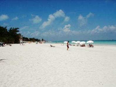
Isle Mujeres, Quintana Roo, Yucatan Mexico
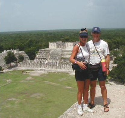
Steve and Gayla join Doann and Wayne of Bali Hai on inland trip to
Chitzen Itza
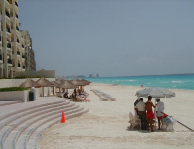
And a day in Cancun Mexico
Gayla’s “counsel warden” Michael Creamer, a land based gringo and his wife Greta, the local Red Cross doctor were not remiss in their duties to keep an eye out for Gayla and Ariel. When the Internet failed to keep in contact with Captain Steve, Michael was there relaying messages through the tourist office and marina’s.
Tom and Pixie of s/v Denuo visit Ariel
July 10, 2001
Log: Leaving anchorage Isle Mujeres for Banco Chinchorro
No wind
Seas flat
Motoring 6 knots
8:30 AM Ariel’s anchor is hauled up by the windless and secured in place on the bow sprit for the over night passage south. We motor over to the fuel dock at the marina inside a lagoon a short distance away to get a half tank of diesel, about 460 liters. Tom and Pixie have already scrubbed Ariel’s bottom and plotted a course. 10:45AM we start the engines, take a 199 compass heading and are on our way. 2:00PM while under way we have managed to take down the new Shade Tree awnings, change the fuel filter on the engine and oil filter on the generator. Necessities taken care of we are now flying all sails, the jib, main and mizzen as we settle down in the cockpit to watch “The Mayan Coast” pass by. We see endless white sand beaches and the sophisticated resorts of Cancun, Playa del Carmen, Xcaret, Akumal, Xel-Ha and the island of Cozumel. 4:00PM we are into a 1 knot current as the water changes to a glaring florescent blue color and the deeper blue off our port where the water drops to a depth of 750feet. We sail the edge for three hours. Pixie has sailed on the edge before. But her experience on the edge is in being air rescued after three days off a sinking boat in the China Sea. She has no problem sleeping in these conditions. Tom has no trouble staying awake having much experience in ‘overnight racing’ and asks to take a double watch. 7:00PM to 12:00AM we motor then sail when the wind picks up to 12 knots. Although there is a counter current we are sailing 7.4 knots just a few miles off shore. 12:00 midnight the night is black as Ariel follows “La Ruta Maya” the Mayan trade route where at it’s peak perhaps up to 4,000 canoes were at sea here at one time. There is no fire flaming through the two windows in El Castillo as we pass the seaside ruins of Tulum. Our friend Michael from Isle Mujeres along with a grant from National Geographic discovered how these fires were used as a lighthouse to guide boats through a small opening in the reef. But being night we chose instead to take Michael’s advice and stay out in the 57 foot depths off shore and sail on. All is stone silent as we leave the ancient ruins of Tulum in our wake.
July 11, 2001
Log: Isle Mujeres to Banco Chinchorro Reef 190 nautical miles
Wind 18 knots
Seas 6 – 8 feet confused at times, 2 knot current
It is a long rough night. Shortly after midnight the conditions change and we are all up and about moving from staterooms to cockpit, to crew cabin to saloon, each trying to find a comfort zone. Hot chocolate and banana bread are laid out for the weary crew but little is touched. By early AM we are motor sailing to keep Ariel on course, even though the 2 knot current is with us the wind is on our bow. The day is spent lounging in the cockpit, watching the flying fish skim across the waves and in anticipation of reaching one of only four atolls in the northern hemisphere. Atolls are coral rings rising perpendicularly from great depths around the edges of steep limestone plateaus enclosing a central deep basin lagoon. They are hard to see, rising suddenly and must be approached with extreme caution. We are headed for Cayo Norte on the Banco Chinchorro. It is the largest atoll which lies 16 miles off the coast of the Mexico, Belize border. More than 26 miles from north to south and 11 miles wide it has caused countless shipwrecks over the centuries. There are said to be recorded over 140 wrecks including a submarine. It is not recommended for the novice. There is a break in the reef at the north end near two cays were we can anchor in a depth of 10 feet. We keep the remains of a wreck in site as Tom at the helms heads for the lighthouse while Steve calls bearings from the navigation station and the girls keep a watch out for coral heads. 4:45 we drop anchor. Inside the reef and protected from the rolling seas we find ourselves transposed into a world apart. Only when we are approached by a Mexican launch with 5 men, 2 armed with automatic rifles, do we feel some anticipation. Pixie and I are below in a flash while Steve carries on doing an official check in and Tom commences to take photo’s. It is a friendly place after all.
July 12, 2001
Log: Anchored inside Banco Chinchorro Reef
Breezy
Seas calm in the lagoon
Tom wakes with the big question……”What time is it on the atoll, central or mountain time?” Steve answers……”out here there is no time atoll”. We are all satisfied with that and decided to spend the day snorkeling. Due to the strong southern current the reefs are festooned in marine life. The reef edge is steeply sloping from 50 to 180 feet and covered with huge coral growths and sponges. We find the coral gardens inside the reef and although much of it is not very vivid Tom spots a beautiful “tree” of coral in purple and green about 6 feet tall waving in the surge. Because the atoll is undisturbed by humans it is a “replenishing area” for many western Caribbean fish and conch. We had heard that the bottom is literally crawling with conch but Tom and Pixie reported seeing only mossy covered stationary shells. We find out later these are probably live conch which we missed the chance to bring one up. But we all spotted the barracuda circling us. They have razor-sharp teeth and can move rapidly striking especially shiny objects. But they are also timid and curious. Tom saw a nurse shark but refrained from pulling it’s tail which is a fun pastime until you wake up a grumpy one.